


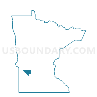
Clara City Voting District, Chippewa County, Minnesota
About
Outline

Summary
| Unique Area Identifier | 601468 |
| Name | Clara City Voting District |
| County | Chippewa County |
| State | Minnesota |
| Area (square miles) | 1.74 |
| Land Area (square miles) | 1.74 |
| Water Area (square miles) | 0.00 |
| % of Land Area | 99.98 |
| % of Water Area | 0.02 |
| Latitude of the Internal Point | 44.95786860 |
| Longtitude of the Internal Point | -95.36682370 |
Maps


Graphs
Select a template below for downloading or customizing gragh for Clara City Voting District, Chippewa County, Minnesota


Neighbors
Neighoring Voting District (by Name) Neighboring Voting District on the Map
- Rheiderland Twp. Voting District, Chippewa County, MN
- Stoneham Twp. Voting District, Chippewa County, MN
Top 10 Neighboring County Subdivision (by Population) Neighboring County Subdivision on the Map
- Clara City city, Chippewa County, MN (1,360)
- Rheiderland township, Chippewa County, MN (269)
- Stoneham township, Chippewa County, MN (241)